Have heavy rains and higher tides flooded roads in your neighborhood? How might an old-fashioned nor’easter, arriving at a full moon high tide impact your access to work, school, or help from emergency vehicles?
Orleans is one of 15 towns working with the Cape Commission to shape town-specific answers to those questions. Initiated in 2021, the Low-Lying Roads Project takes a hard look at vulnerabilities in the roadway network.
With funding support from the U.S. Economic Development Administration and the Massachusetts Municipal Vulnerability Preparedness program, the Commission contracted with the Woods Hole Group (WHG) to conduct vulnerability assessments of roadway segments, bridges, and culverts due to flooding from the combined effects of sea level rise and storm surge.
The accompanying table lists high priority road segments identified in the Cape Cod Commission Low-Lying Roads Report Report for Orleans. As the table indicates, the risk of flooding in multiple neighborhoods is real. To see the full list, please go https://www.capecodcommission.org/our-work/low-lying-roads-orleans/
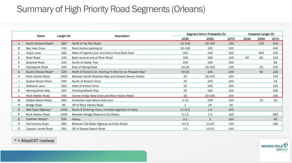
What’s next? As the table suggests, the risk of flooding in multiple neighborhoods is real.
Options range from gray/built infrastructure (drains, pipes, basins) to green infrastructure to managed retreat. Residents recognize that no action is not an option.
Initial Action Steps
Orleans’ participation in the Low-Lying Roads Project afforded the town the opportunity to identify two sections of road for which WHG would develop conceptual design plans and associated adaptation solutions.
Public meetings discussing the findings acknowledged the challenge of selecting two road sections for immediate study when multiple sites cited as High Priority represented the sole access to year-round residences. Skaket Road at Gull Lane and at Seabreeze Lane were selected. In April 2023, the Town received conceptual design plans drafted by the Woods Hole Group The Town is now positioned to act on these plans.
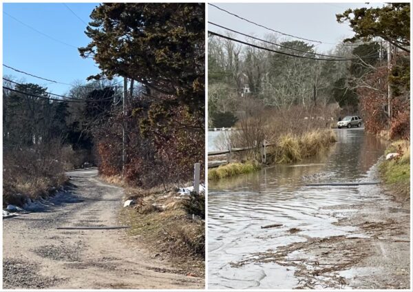
The first of the two accompanying photos was taken at high tide on January 10, 2024. Arey’s Lane, South Orleans (near the Arey’s Pond Boat Yard), was underwater due to heavy rains, storm surge, and a King Tide. The road was impassable for some vehicles for part of the day. The second photo was taken at high tide on a day without storm surge or astronomically high tide.
When conditions cause an extraordinarily high tide, as was the case on January 10, residents in this area have the option of using another exit route, via Kescayoganset Road and Herring Brook Way. However, flooding at the lowest point on that route is typically as deep as or deeper than flooding at Arey’s Pond Boat Yard.